Montant total (1 article articles) :
Destination de la commande :

carte crus eaux de vie charentes cognac de guillon jean marie, Edition originale (1 résultats)
Commentaires
Passer aux résultats principaux de la recherche
Filtres de recherche
Type d'article
- Tous les types de produits
- Livres (1)
- Magazines & Périodiques (Aucun autre résultat ne correspond ŕ ces critčres)
- Bandes dessinées (Aucun autre résultat ne correspond ŕ ces critčres)
- Partitions de musique (Aucun autre résultat ne correspond ŕ ces critčres)
- Art, Affiches et Gravures (Aucun autre résultat ne correspond ŕ ces critčres)
- Photographies (Aucun autre résultat ne correspond ŕ ces critčres)
- Cartes (Aucun autre résultat ne correspond ŕ ces critčres)
- Manuscrits & Papiers anciens (Aucun autre résultat ne correspond ŕ ces critčres)
Etat
- Tous
- Neuf (Aucun autre résultat ne correspond ŕ ces critčres)
- Ancien ou d'occasion (1)
Reliure
- Toutes
- Couverture rigide (Aucun autre résultat ne correspond ŕ ces critčres)
- Couverture souple (Aucun autre résultat ne correspond ŕ ces critčres)
Particularités
- Ed. originale (1)
- Signé (Aucun autre résultat ne correspond ŕ ces critčres)
- Jaquette (Aucun autre résultat ne correspond ŕ ces critčres)
- Avec images (1)
- Sans impressions ŕ la demande (1)
Langue (1)
Prix
- Tous les prix
- Moins de EUR 20 (Aucun autre résultat ne correspond ŕ ces critčres)
- EUR 20 ŕ EUR 45 (Aucun autre résultat ne correspond ŕ ces critčres)
- Plus de EUR 45
Livraison gratuite
- Livraison gratuite ŕ destination de Etats-Unis (Aucun autre résultat ne correspond ŕ ces critčres)
Pays
Evaluation du vendeur
-
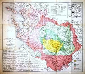
Carte des crus des eaux-de-vie des Charentes ou de Cognac par J. M. Guillon, Inspecteur de la Viticulture, Directeur de la Station Viticole de Cognac. Cette carte a été approuvée par le Ministre de L'Agriculture comme conforme dans ses limites extérieures au Décret du 1er Mai 1909 et par la Chambre de Commerce de Cognac pour ce qui concerne la subdivision des Crus
Edité par F. Champenois, Imprimeur-Éditeur (Gravé par A. Simon), Paris, 1909
Vendeur : Földvári Books, Budapest, Hongrie
Membre d'association : ILAB MAE
Évaluation du vendeur 5 sur 5 étoiles

Edition originale
EUR 1 320
Autre deviseEUR 19,50 expédition depuis Hongrie vers Etats-UnisQuantité disponible : 1 disponible(s)
Ajouter au panierIn publisher's folder. First edition.With a mounted photographic advertisement of the Tesseron distillery at Châteauneuf-sur-Charente. In publisher's folder. 720 × 620 mm. In May 1909 a very precise definition of the outer boundaries of the cognac region and the appellation control (appellation d'origine contrôlée) was made by law, based on characteristics of the soil defined by the geologist Henry Coquand (Description physique, géologique, paléontologique et minéralogique du département de la Charente; 1858). This map accompanied the law, shows the Cognac region and its eight zones (later reduced to six): Grande (or Fine) Champagne, Petite Champagne, Borderies, Premier Bois, Fins Bois, Bons Bois, Bois Ordinaires and Bois Communs dits ŕ Terroir. A definition and a short description of each areas by Guillon printed under the cartouche. Folded as published. In fine condition. First edition.With a mounted photographic advertisement of the Tesseron distillery at Châteauneuf-sur-Charente.