
Montant total (1 article articles) :
Destination de la commande :

mer baltique: Cartes (10 résultats)
Commentaires
Passer aux résultats principaux de la recherche
Filtres de recherche
Type d'article
- Tous les types de produits
- Livres (464)
- Magazines & Périodiques (14)
- Bandes dessinées (Aucun autre résultat ne correspond ŕ ces critčres)
- Partitions de musique (Aucun autre résultat ne correspond ŕ ces critčres)
- Art, Affiches et Gravures (6)
- Photographies (10)
- Cartes (10)
- Manuscrits & Papiers anciens (Aucun autre résultat ne correspond ŕ ces critčres)
Etat
- Tous
- Neuf (Aucun autre résultat ne correspond ŕ ces critčres)
- Ancien ou d'occasion (10)
Reliure
- Toutes
- Couverture rigide (Aucun autre résultat ne correspond ŕ ces critčres)
- Couverture souple (1)
Particularités
- Ed. originale (2)
- Signé (Aucun autre résultat ne correspond ŕ ces critčres)
- Jaquette (Aucun autre résultat ne correspond ŕ ces critčres)
- Avec images (9)
- Sans impressions ŕ la demande (10)
Langue (3)
Livraison gratuite
- Livraison gratuite ŕ destination de Etats-Unis (Aucun autre résultat ne correspond ŕ ces critčres)
Pays
Evaluation du vendeur
-
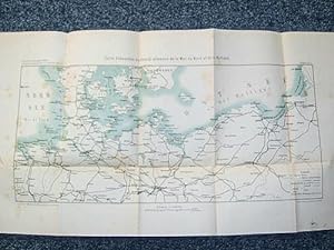
Littoral de la Mer Baltique
Date d'édition : 1879
Vendeur : Antiqua Print Gallery, London, Royaume-Uni
Évaluation du vendeur 4 sur 5 étoiles

Carte
EUR 13,88
Autre deviseEUR 8,79 expédition depuis Royaume-Uni vers Etats-UnisQuantité disponible : 1 disponible(s)
Ajouter au panierEtat : Fair. EUROPE. Littoral de la Mer Baltique(Baltic); Baltic Sea 1879 old antique map. Antique map; Engraved by Th. Duvotenay (1879). 17.0 x 11.0cm, 6.75 x 4.25 inches. Condition: Fair: Spotting. If the print has been scanned in black and white, any foxing or spotting highlighted in this statement may appear brown on the actual print. There is nothing printed on the reverse side, which is plain.
-

Carte de la Mer Baltique et des Pays Scandinaves.
Edité par LECONTE A.
Vendeur : Le-Livre, SABLONS, France
Membre d'association : ILAB
Évaluation du vendeur 5 sur 5 étoiles

Carte
EUR 16,95
Autre deviseEUR 18 expédition depuis France vers Etats-UnisQuantité disponible : 1 disponible(s)
Ajouter au panierPas de couverture. Etat : bon. RO80010824: Non daté. In-Plano. En feuillets. Bon état, Couv. convenable, Dos satisfaisant, Intérieur frais. Carte dépliante en couleurs, de 100/75 cm, hors-texte. Pas de plats de couverture. . . . Classification Dewey : 912-Atlas, cartes et plans.
-
Guerre de 1870. Carte d'ensemble du littoral allemande de la Mer du Nord ŕ la Baltique.
Edité par E.S. Mittler et Fils, 1871
Langue: français
Vendeur : Librairie du Cardinal, GRADIGNAN, France
Évaluation du vendeur 5 sur 5 étoiles
Carte
EUR 54
Autre deviseEUR 10 expédition depuis France vers Etats-UnisQuantité disponible : 1 disponible(s)
Ajouter au paniersouple. Etat : Bon. Carte rédigée par la Section historique du Grand Etat Major Prussien, 1 carte au 1/2 000 000 čme ; 570 x 315 mm, E.S. Mittler et Fils, Greve Imp., s.d. (circa 1871) Carte réalisée par la Section historique du Grand Etat Major Prussien au lendemain de la guerre de 1870, en bon état (qq. rouss.) Langue: Français.
-
Carte mer Dannemark, mer baltique, Sanson-Jaillot 1693
Edité par Mortier Pierre, 1661-1711, 1693
Vendeur : Hammelburger Antiquariat, Hammelburg, Allemagne
Évaluation du vendeur 4 sur 5 étoiles
Carte
EUR 500
Autre deviseEUR 30 expédition depuis Allemagne vers Etats-UnisQuantité disponible : 1 disponible(s)
Ajouter au panierKein Einband. Etat : Gut. Carte mer Dannemark, mer baltique, Sanson-Jaillot 1693: " CARTE DE LA MER DE DANNEMARK ET DES ENTREES DANS LA MER BALTIQUE." Old coloured map by Sanson-Jaillot, Published by Pierre Mortier 1693, size of the leaf: 63x97 cm., some restorations of the oxidated parts of the green colours. For more informations please klick the below link. Altkolorierte Karte von Dänemark, diverse hinterlegte Koloritbrüche.
-
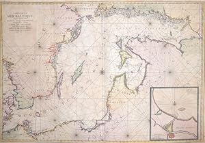
Carte de la Mer Baltique contenant les bancs, isles et costes.
Edité par Artist: Mortier Peter ( - 1711 ) Amsterdam; issued in: Paris; - Pieter Mortier (1661?1711) was an 18th-century mapmaker and engraver from the Northern Netherlands Mortier had a partnership with Johannes Covens I (1697-1774) and founded the map publishing company Covens & Mortier (1721-1866) Mortier being French himself had easy access to French cartographers such as De L'Isle Sanson Jaillot de Fer and De Wit Consequently much of Mortier's business was built upon leveraging the sophisticated Dutch printing establishment to issue embellished high quality editions of previously contemporary French maps In the greater context of global cartography this was a significant advantage as most Dutch map publishes had at this point fallen into the mia, 1661
Vendeur : Antique Sommer& Sapunaru KG, München, Allemagne
Membre d'association : ILAB VDA
Évaluation du vendeur 2 sur 5 étoiles

Carte
EUR 1 930
Autre deviseEUR 45 expédition depuis Allemagne vers Etats-UnisQuantité disponible : 1 disponible(s)
Ajouter au panierTechnic: Copper print, colorit: original coloredcondition: Very good, size (in cm): 60 x 80 cm; - Map shows the total East Sea with the coasts of Sweden, Finnland, Russia, Estland, Lettland,Lithuania and Poland.
-
Carte de la Mer Baltique Contenant les Bancs, Isles et Costes Comprises entre l Isle de Zelande 63,7 x 96 cm Carte de la Mer Baltique Contenant les Bancs, Isles et Costes Comprises entre l Isle de Zelande et l Extrimite du Golfe de Finlande 1693 MORTIER P. Amsterdam, 1693 An important chart of the Baltic Sea with the coasts of Sweden, Finland, Russia, Estonia, Lettland, Lithuania and Poland. Printed on thick paper, coloured by an contemporary hand, only little brownish. VERY SCARCE MAP OF PIERRE MORTIER, first edition, anno 1693
Date d'édition : 1693
Vendeur : Hammelburger Antiquariat, Hammelburg, Allemagne
Évaluation du vendeur 4 sur 5 étoiles
Carte
EUR 2 900
Autre deviseEUR 30 expédition depuis Allemagne vers Etats-UnisQuantité disponible : 1 disponible(s)
Ajouter au panierKein Einband. Etat : Gut. Carte de la Mer Baltique Contenant les Bancs, Isles et Costes Comprises entre l Isle de Zelande 63,7 x 96 cm Carte de la Mer Baltique Contenant les Bancs, Isles et Costes Comprises entre l Isle de Zelande et l Extrimite du Golfe de Finlande 1693 MORTIER P. Amsterdam, 1693 An important chart of the Baltic Sea with the coasts of Sweden, Finland, Russia, Estonia, Lettland, Lithuania and Poland. Printed on thick paper, coloured by an contemporary hand, only little brownish. VERY SCARCE MAP OF PIERRE MORTIER, first edition, anno 1693.
-

Carte Réduite de la Mer Baltique. Vi.e Fueille Contenant Le Golfe de Finland d'aprčs les Cartes Suédoises et Russes les plus récentres.
Date d'édition : 1815
Vendeur : Altea Antique Maps, London, Royaume-Uni
Membre d'association : ABA ILAB PBFA
Évaluation du vendeur 5 sur 5 étoiles
Carte
EUR 1 206,62
Autre deviseEUR 41 expédition depuis Royaume-Uni vers Etats-UnisQuantité disponible : 1 disponible(s)
Ajouter au panierParis: 1815. 630 x 930mm. A detailed sea-chart of the Gulf of Finland, marking three capital cities: Helingfors (Helinki, when it had been the Finnish capital for only three years), St Petersburg and Revel (Talinn, Estonia). The land areas are filled with coastal profiles and six inset details of ports, including Talinn. The dedication is to Arnail François (1757-1852), marquis de Jaucourt. With the Bourbon Restoration in 1814 he became a minister of state, remaining loyal to Louis XVIII during Napoleon's Hundred Days. He was only Minister for the Navy (the position he held when he supervised this chart) from July to September 1815, after which he retired from public office.
-

Estats des Couronnes de Dannemark, Suede, et Pologne sur la Mer Baltique.
Date d'édition : 1705
Vendeur : Altea Antique Maps, London, Royaume-Uni
Membre d'association : ABA ILAB PBFA
Évaluation du vendeur 5 sur 5 étoiles
Carte
EUR 1 146,29
Autre deviseEUR 41 expédition depuis Royaume-Uni vers Etats-UnisQuantité disponible : 1 disponible(s)
Ajouter au panierParis, 1705. Two sheets conjoined, total 440 x 700mm. Bottom left margin restored, two tears skillfully repaired. A map of the countries surrounding the Baltic but extending west through Germany, Holland, to southern England, engraved by van Loon and first published 1700. The focus of the map is the Great Northern War (1700-1721), in which Russia fought to regain Ingria from Sweden in order to have a sea port on the Baltic, but involving many other powers (including Britain and the Ottoman Empire). In 1703 the Russians took Nyenskans, a Swedish fortress at the mouth of the River Neva and renamed it after the tsar; only two years later this map was updated to mark 'Petersbourg'.
-

Kupferstich- Karte, b. H. Jaillot aus "Neptune Francais", "Carte de la Mer de Dannemark et des entrees dans la Mer Baltique Contenant les Bancs, Passes, Isles et Costes depuis Norden et Le Cap Der-Neus jusques a Rostock et Valsterbon".
Langue: allemand
Vendeur : Antiquariat Clemens Paulusch GmbH, Berlin, Allemagne
Membre d'association : ILAB VDA
Évaluation du vendeur 5 sur 5 étoiles
Carte Edition originale
EUR 900
Autre deviseEUR 26,90 expédition depuis Allemagne vers Etats-UnisQuantité disponible : 1 disponible(s)
Ajouter au paniermit altem Grenzkolorit, dat. 1693, 60 x 88,5 Pastoreau, Le Neptune Francais A/3. Erste Ausgabe der westorientierten Karte der Gewässer um Dänemark. Sie reicht von den Ostfriesischen Inseln im Westen bis Barth im Osten, Im Norden bis Oslo, im Süden bis Hamburg. Wie üblich von zwei Platten gestochen und zusammen gesetzt. Kleinere Randläsuren restauriert.
-
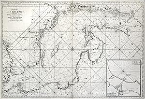
Kupferstich- Karte, v. H. van Loon aus Neptune Francois, "Carte de la Mer Baltique, Contenant les Bancs, Isles et Costes comprisens entre l'Isle de Zelande et l'Extremité du Golfe de Finlande.".
Langue: allemand
Vendeur : Antiquariat Clemens Paulusch GmbH, Berlin, Allemagne
Membre d'association : ILAB VDA
Évaluation du vendeur 5 sur 5 étoiles
Carte Edition originale
EUR 1 300
Autre deviseEUR 26,90 expédition depuis Allemagne vers Etats-UnisQuantité disponible : 1 disponible(s)
Ajouter au panier1753, 61 x 89,5 Pastoureau S. 355, Neptune C; Mare Balticum S. 269; vgl. Tooley, Scandinavia 340 (EA bei Jaillot/Mortier). - Seekarte des gesamten Ostseeraumes. Genauer Nachstich der Erstausgabe von 1693, hier aus einer Ausgabe 1753. mit zusätzlicher Angaben der Längengrade. Reicht von Fehmarn im Westen bis zur Mündung der Newa im Osten, von Forsmark im Noren bis zum Großen Haff im Süden, mit Insetkarte der Umgebung von Danzig. Hervorranegnder kontrastreicher Druck auf dickem Papier.


