Montant total (1 article articles) :
Destination de la commande :

typus orbis terrarum de abraham ortelius (9 résultats)
Commentaires
Passer aux résultats principaux de la recherche
Filtres de recherche
Type d'article
- Tous les types de produits
- Livres (1)
- Magazines & Périodiques (Aucun autre résultat ne correspond ŕ ces critčres)
- Bandes dessinées (Aucun autre résultat ne correspond ŕ ces critčres)
- Partitions de musique (Aucun autre résultat ne correspond ŕ ces critčres)
- Art, Affiches et Gravures (Aucun autre résultat ne correspond ŕ ces critčres)
- Photographies (Aucun autre résultat ne correspond ŕ ces critčres)
- Cartes (8)
- Manuscrits & Papiers anciens (Aucun autre résultat ne correspond ŕ ces critčres)
Etat
- Tous
- Neuf (Aucun autre résultat ne correspond ŕ ces critčres)
- Ancien ou d'occasion (9)
Reliure
- Toutes
- Couverture rigide (Aucun autre résultat ne correspond ŕ ces critčres)
- Couverture souple (Aucun autre résultat ne correspond ŕ ces critčres)
Particularités
- Ed. originale (1)
- Signé (Aucun autre résultat ne correspond ŕ ces critčres)
- Jaquette (Aucun autre résultat ne correspond ŕ ces critčres)
- Avec images (9)
- Sans impressions ŕ la demande (9)
Langue (3)
Livraison gratuite
- Livraison gratuite ŕ destination de Etats-Unis (Aucun autre résultat ne correspond ŕ ces critčres)
Pays
Evaluation du vendeur
-

"La Mans Cenomano Rum Typus" - Maine Le Mans / France Frankreich / carte map Karte / Epitome du theatre du monde / Theatro del Mondo / Theatrum orbis terrarum
Edité par Antwerp, Plantin for Philippe Galle, 1598
Langue: français
Vendeur : Antiquariat Steffen Völkel GmbH, Seubersdorf, Allemagne
Membre d'association : ILAB VDA
Évaluation du vendeur 5 sur 5 étoiles

Carte
EUR 19,99
Autre deviseEUR 32 expédition depuis Allemagne vers Etats-UnisQuantité disponible : 1 disponible(s)
Ajouter au panierSeltene Kupferstich-Karte von Abraham Ortelius von 1598. Mit französischem Text auf der Rückseite. -- Bildmaße: ca. 7,8 x 11 cm. -- etwas fleckig im rechten Außenrand, sonst gut erhalten. || Rare map by Abraham Ortelius from 1598. With French text verso. -- somewhat stained in the right margin, otherwise in very good condition. Sprache: Französisch Gewicht in Gramm: 10.
-

"Lotharingia / Lotharingiae Typus" - Lothringen Lorraine Nancy Metz / France Frankreich / carte map Karte / Epitome du theatre du monde / Theatro del Mondo / Theatrum orbis terrarum
Edité par Antwerp, Plantin for Philippe Galle, 1598
Langue: français
Vendeur : Antiquariat Steffen Völkel GmbH, Seubersdorf, Allemagne
Membre d'association : ILAB VDA
Évaluation du vendeur 5 sur 5 étoiles
Carte
EUR 29,99
Autre deviseEUR 32 expédition depuis Allemagne vers Etats-UnisQuantité disponible : 1 disponible(s)
Ajouter au panierSeltene Kupferstich-Karte von Abraham Ortelius von 1598. Mit französischem Text auf der Rückseite. -- Bildmaße: ca. 7,8 x 11 cm. -- gut erhalten. || Rare map by Abraham Ortelius from 1598. With French text verso. -- in very good condition. Sprache: Französisch Gewicht in Gramm: 10.
-

"Carthagin. Portus / Carthaginis celeberrimi sinus typus" - Cartage Tunisia Tunesien Tunis Africa Afrika Afrique / carte map Karte / Epitome du theatre du monde / Theatro del Mondo / Theatrum orbis terrarum
Edité par Antwerp, Plantin for Philippe Galle, 1598
Langue: français
Vendeur : Antiquariat Steffen Völkel GmbH, Seubersdorf, Allemagne
Membre d'association : ILAB VDA
Évaluation du vendeur 5 sur 5 étoiles
Carte
EUR 39,99
Autre deviseEUR 32 expédition depuis Allemagne vers Etats-UnisQuantité disponible : 1 disponible(s)
Ajouter au panierSeltene Kupferstich-Karte von Abraham Ortelius von 1598. Mit französischem Text auf der Rückseite. -- Bildmaße: ca. 7,8 x 11 cm. -- gut erhalten. || Rare map by Abraham Ortelius from 1598. With French text verso. -- in very good condition. Sprache: Französisch Gewicht in Gramm: 10.
-

"Forum Iulii / Fori Iuly vulgo friuli typus" - Friuli Friaul Udine Italia Italy Italien / carte map Karte / Epitome du theatre du monde / Theatro del Mondo / Theatrum orbis terrarum
Edité par Antwerp, Plantin for Philippe Galle, 1598
Langue: français
Vendeur : Antiquariat Steffen Völkel GmbH, Seubersdorf, Allemagne
Membre d'association : ILAB VDA
Évaluation du vendeur 5 sur 5 étoiles
Carte
EUR 69,99
Autre deviseEUR 32 expédition depuis Allemagne vers Etats-UnisQuantité disponible : 1 disponible(s)
Ajouter au panierSeltene Kupferstich-Karte von Abraham Ortelius von 1598. Mit französischem Text auf der Rückseite. -- Bildmaße: ca. 7,8 x 11 cm. -- teils fleckig, mit einem kleinen Wurmloch, sonst gut erhalten. || Rare map by Abraham Ortelius from 1598. With French text verso. -- partly stained, with a worm hole, otherwise in very good condition. Sprache: Französisch Gewicht in Gramm: 10.
-

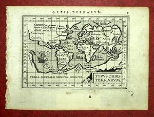
"Typus Orbis Terrarum" - World Map Weltkarte Mappemonde / Epitome du theatre du monde / Theatro del Mondo / Theatrum orbis terrarum
Edité par Antwerp, Plantin for Philippe Galle, 1598
Langue: français
Vendeur : Antiquariat Steffen Völkel GmbH, Seubersdorf, Allemagne
Membre d'association : ILAB VDA
Évaluation du vendeur 5 sur 5 étoiles
Carte
EUR 400
Autre deviseEUR 32 expédition depuis Allemagne vers Etats-UnisQuantité disponible : 1 disponible(s)
Ajouter au panierSeltene Kupferstich-Karte von Abraham Ortelius von 1598. Mit französischem Text auf der Rückseite. -- Bildmaße: ca. 7,8 x 11 cm. -- gut erhalten. || Rare map by Abraham Ortelius from 1598. With French text verso. -- in very good condition. Sprache: Französisch Gewicht in Gramm: 10.
-

Typus Orbis Terrarum
Edité par Anversa, 1592
Vendeur : Libreria Ex Libris ALAI-ILAB/LILA member, Roma, Italie
Membre d'association : ALAI ILAB
Évaluation du vendeur 5 sur 5 étoiles
Carte
EUR 7 000
Autre deviseEUR 30 expédition depuis Italie vers Etats-UnisQuantité disponible : 1 disponible(s)
Ajouter au panierCarta geografica originale (cm. 49x35,5 piů ampi margini bianchi) tratta dal 'Theatrum Orbis Terrarum'. Bella coloritura antica all'acquarello. Testo in lingua latina al verso. Lievi tracce di restauro e rinforzo alla piegatura centrale, peraltro esemplare in ottimo stato di conservazione. Terza versione del mappamndo di Ortelius: al posto delle nuvole delle due precedenti, č presente una ricca decorazione in stile fiammingo con un medaglione in ciascuno dei quattro angoli (vi sono trascritti testi classici, due di Cicerone e due di Seneca).Cfr. Van den Broecke, n. 3; Shirley ('The mapping of the world', n. 336): 'The oval world map used previously has been updated in two major respects: South America now assumes the more correct shape anticipated in stae 3 of Ortelius' second plate, and the Solomon Isles are marked for the first time'.
-
TYPUS ORBIS TERRARUM, MAPPEMONDE tirée de THEATRUM ORBIS TERRARUM
Edité par Abraham ORTELIUS
Vendeur : Librairie Maxime Katz, Villeurbanne, FR, France
Évaluation du vendeur 5 sur 5 étoiles
Carte Edition originale
EUR 1 000
Autre deviseEUR 36 expédition depuis France vers Etats-UnisQuantité disponible : 1 disponible(s)
Ajouter au panierPas de couverture. Etat : Trčs bon. Edition originale. MAPPEMONDE Carte du monde tirée de l'épitome du THEATRUM ORBIS TERRARUM Par Abraham ORTELIUS A Anvers 1601 TYPUS ORBIS TERRARUM Beau tirage original 16 x 12 centimetres Bon état TRES RARE TIRAGE ORIGINAL DE 1601.
-
World and continents - Typus Orbis Terrarum + Europa + Asia + Africa + Novus Orbis
Edité par Antwerp, 1598
Vendeur : Antikvariat Krenek, Prag, Rébublique tchčque
Membre d'association : ILAB
Évaluation du vendeur 5 sur 5 étoiles
EUR 875,07
Autre deviseEUR 14,50 expédition depuis Rébublique tchčque vers Etats-UnisQuantité disponible : 1 disponible(s)
Ajouter au panierWorld and continents. "Typus Orbis Terrarum" + "Europa" + "Asia" + "Africa" + "America sive Novus Orbis". Orig. copperplate engravings from the French edition of A. Ortelius' Epitome, published in Antwerp by Plantin Press for F. Galle, 1598. Each map with ornamental title-cartouche (the map of Europe with engraved title in the map) and Latin title above the map. The map of America with a ship. Each one 8:11 cm (3 1/4 x 4 1/4 inch.). Koeman III; maps 0001:332A, 1000:332, 8000:332, 8600:332, 9000:332; ed. 332:03 (1598 Epitome). - A very decorative set of 5 miniature maps showing the World and the continents.
-
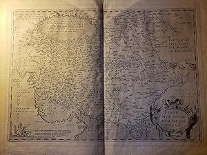
Original Map - "Persici Sive Sophorum Regni Typus" and One Accompanying Page from Ortelius's Theatrum Orbis Terrarum
Langue: latin
Vendeur : Barry Cassidy Rare Books, Sacramento, CA, Etats-Unis
Évaluation du vendeur 5 sur 5 étoiles
Carte
EUR 451,42
Autre deviseEUR 5,26 expédition vers Etats-UnisQuantité disponible : 1 disponible(s)
Ajouter au panierNo Binding. Etat : Collectible-Very Good. Original publisher's black and white map showing Persia. Map text is in Latin. No date, circa 1612. Map with margins measures 22 1/2" x 17"; actual map area measures 19 1/2" x 13 3/4." Map has an original vertical fold line in the center. On the back is one page from the atlas which also has text in Latin and "64" printed in the lower-right corner. Map and text are very clean and intact. Very minimal age wear. A few pieces of tape on the top edge which do not affect text or illustrations. Map shows cities, rivers, and other natural features such as seas and mountains. Axes of latitude and longitude along the map border. Title is printed in a decorative cartouche in the lower-right corner. A beautiful map with great historical significance. Abraham Ortelius (1527-1598) was a Brabantian cartographer and geographer. He is known for the Theatrum Orbis Terrarum, which was first published in 1570 and is the first modern world atlas of the world. This particular map is one of the few plates that remained unchanged throughout the atlas's entire publication. The map was drawn from the 1564 map of Asia Minor by Giacomo Gastaldi (c. 1500-1566), who was an Italian cartographer, astronomer, and engineer, and Ortelius's own map of Asia from 1567.